

• Moondipper and Pine Burl Hot Springs are one of the five sets of soaking pools near Boiling Springs
Moondipper and Pine Burl Hot Springs are nestled along Dash Creek near the Middle Fork Payette River in the Boise National Forest. These springs are one of five soaking areas accessible via hiking from Boiling Springs. To reach them, take a moderate 4.7-mile (7.6 km) out-and-back trail with about 420 feet of elevation gain. Located between Little Dipper and Butterfly/Groundhog Hot Springs, these mid-trail pools offer a nice balance of accessibility and scenic charm.
Best time to visit is from May through October, when water levels are lower and the trail is more navigable.
Geothermal Water & Soaking
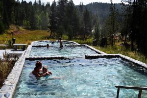
Water emerges from the source at 136°F and flows down a cliff face into volunteer-built soaking pools. The two pools—Moondipper and Pine Burl—are about 80 yards apart:
- Moondipper is a large, sandy-bottomed pool with canyon views—great for groups or a long soak.
- Pine Burl is a smaller, rock-and-mortar pool with more privacy, suited for couples or solo bathers.
Temperatures range from 106°F to 110°F, depending on season and use. Pine Burl is outfitted with hot and cold water pipes, allowing you to fine-tune your soak. Be sure to leave the cold water running when you finish helping prevent algae buildup.
If Moondipper feels too hot, you can cool it down by bucketing in creek water.
Clothing is optional at both springs.

Camping
Boiling Springs Campground sits at the trailhead to the springs, 0.25 miles away from the Boiling Springs.
You can rent the cabin through recreation.gov.
Moondipper and Pine Burl Hot Springs | Facts
Location: 23 miles southwest • Central Idaho • USA
Open: Year-round, but the road is covered by snow during winter
Development: Undeveloped
Clothing: Optional
Amenities: None
Hiking distance: 2.35 miles
Road access: Any vehicle, except during winter
Day-use fees: None
Managed by: U.S. Forest Service
Elevation: 4,200 ft (1,280 m)
Water T° (source): 136°F (58°C)
Water T° (pools): 106°F - 110°F (41°C - 43°C)
Odor None
More Adventures


Directions to Boiling Springs
From Crouch,
- Take S Middlefork Road for 3.2 miles
- Turn left onto Middlefork Road and follow it for 13.9 miles
- Turn left onto Forest Road 698/Middlefork Road and follow it for 5.4 miles.
Take a 2.35-mile one-way hike from the trailhead along the Middle Fork Payette River.
The path with steep and slippery sections follows the river's western edge. It is the safer option when the water level is high.
The Middle Fork Trail is more direct, but you must cross the river several times on your way. During the dry season, the river is usually only ankle-deep.
GPS (Trailhead): N 44°21.604' W 115°51.594' | 44.36018, -115.85986
GPS (Moondipper Hot Springs): N 44°22.962' W 115°50.442' | 44.3827,-115.8407
GPS (Pine Burl Hot Springs): N 44°22.968' W 115°50.490' | 44.3828,-115.8415