

• Bagby Hot Springs offers a serene soaking experience in the dense Mt. Hood National Forest
Managed by the Forest Service, Bagby Hot Springs is nestled in the lush, old-growth Mount Hood National Forest, 38 miles southeast of Estacada and 67 miles from Portland. This scenic getaway, featuring primitive facilities, is open 24 hours a day, year-round.
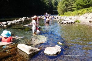
There is no parking near the hot springs. From the Bagby Trailhead, you'll hike for about 1.4 miles through an ancient rainforest along the Collawash River. This refreshing, relatively easy hike takes around 45-60 minutes. After crossing three bridges, you’ll arrive at Bagby Hot Springs, where charming wooden structures are tucked away in the dense, magical forest.
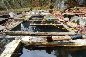
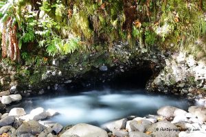
The hot springs emerge from two sources at 136°F, flowing through hollowed-out cedar logs to the large open-sided tub and private bathhouses. The mineral water is too hot for immediate soaking, so it is mixed with cooler water from nearby springs before use.

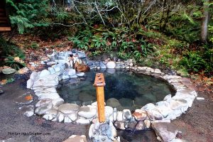
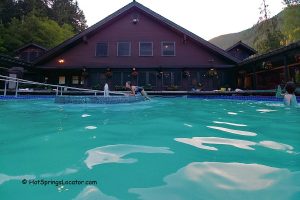
The main bathhouse at Bagby Hot Springs features five private cedar wood tubs, each located in its own room. The lower open-deck bathhouse has three smaller log tubs and one large family tub. About 100 yards from the main bathhouse, an open bathhouse offers a large communal tub that can hold six to eight people. Nudity is only permitted in the private rooms of the main bathhouse.
Alcohol is prohibited at Bagby Hot Springs.
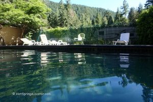
The springs can become crowded on weekends and holidays, and waiting times for tubs vary based on the number of visitors.


Brief History of Bagby Hot Springs
Bagby Hot Springs is named after Bob Bagby, a hunter who discovered the area in 1880.
In 1913, the Forest Service Guard station was built near the springs for use during the summer months. In the 1920s, additional bathhouses and cabins were constructed. Although the guard station moved to Oak Grove in 1974, the bathhouses remained in use. The original Bagby Guard Station was later renovated and added to the National Register of Historic Places, though public access is not permitted.
In 1979, a fire caused by a candle left burning by a bather destroyed the bathhouse. It took more than five years to rebuild the facilities.
Video
Bagby Hot Springs | Facts
Location: 38 miles southeast of Estacada • Oregon Cascade Mountains • USA
Open: Year-round, 24 hours
Development: Semi-developed, rustic bathhouses, and wood tubs
Clothing: Required in public places
Amenities: No services are available; a pit toilet.
Accommodations: Campsites - 0.25 miles; Kingfisher Campground - 4 miles east; Motels in Estacada - 38 miles west
Hiking distance: 1.4 miles
Road Access: Any vehicle
Day-use: Yes with fees, kids under 11 - free
Managed by: US Forest Service
Elevation: 2,280 ft (695 m)
Water T°: 120°F (49°C) - 138°F (59°C)
Water acidity level: Alkaline (pH=9.7)
Springs Type: Mixed
Flow rate: 26 gallon/min (100 l/min)
Chemical used: None
Average dissolved solids: 260 Mg/L
Cations | Anions |
More Adventures

Directions to Bagby Hot Springs
From Portland,
- From I-205 take exit 12 in Clackamas and drive along Highway 224 East
- Highway 224 becomes FR 46 after Ranger Station
- Continue for 3.5 miles to Forest Road 63
- Turn right onto Forest Road 63 and follow 3 miles to FR 70
- Turn right onto FR 70 and follow the next 5.5 miles to Bagby Trailhead
- Bagby Trailhead and parking facility are on the left.
From Salem,
- Drive along Highway 213 to Molalla
- Turn right onto Highway 211
- Before Estacada, turn right onto Highway 224
- Drive on Highway 224 east for 26 miles from Estacada to the Ripplebrook Ranger Station
- Highway 224 becomes the road 46 after Ranger Station
- Continue for 3.5 miles to Forest Road 63
- Turn right onto Forest Road 63
- Drive 3 miles to FR 70, turn right onto FR 70
- Follow next 5.5 miles to Bagby Trailhead
- Bagby Trailhead and parking facility are on the left.
Phone: 503-630-6861
GPS (Trailhead): N 44°57.263' W 122°10.228' | 44.9544, -122.1705
GPS (Hot Springs): N 44°56.120' W 122°10.422 | 44.9353,-122.1737
Lauren S. Forcella. "Geochemistry of Thermal and Mineral Waters in the Cascade Mountains of Western North America". 1981
"Geothermal Information Layer for Oregon". www.oregongeology.org